First, if you will look at the picture from wikimedia commons:
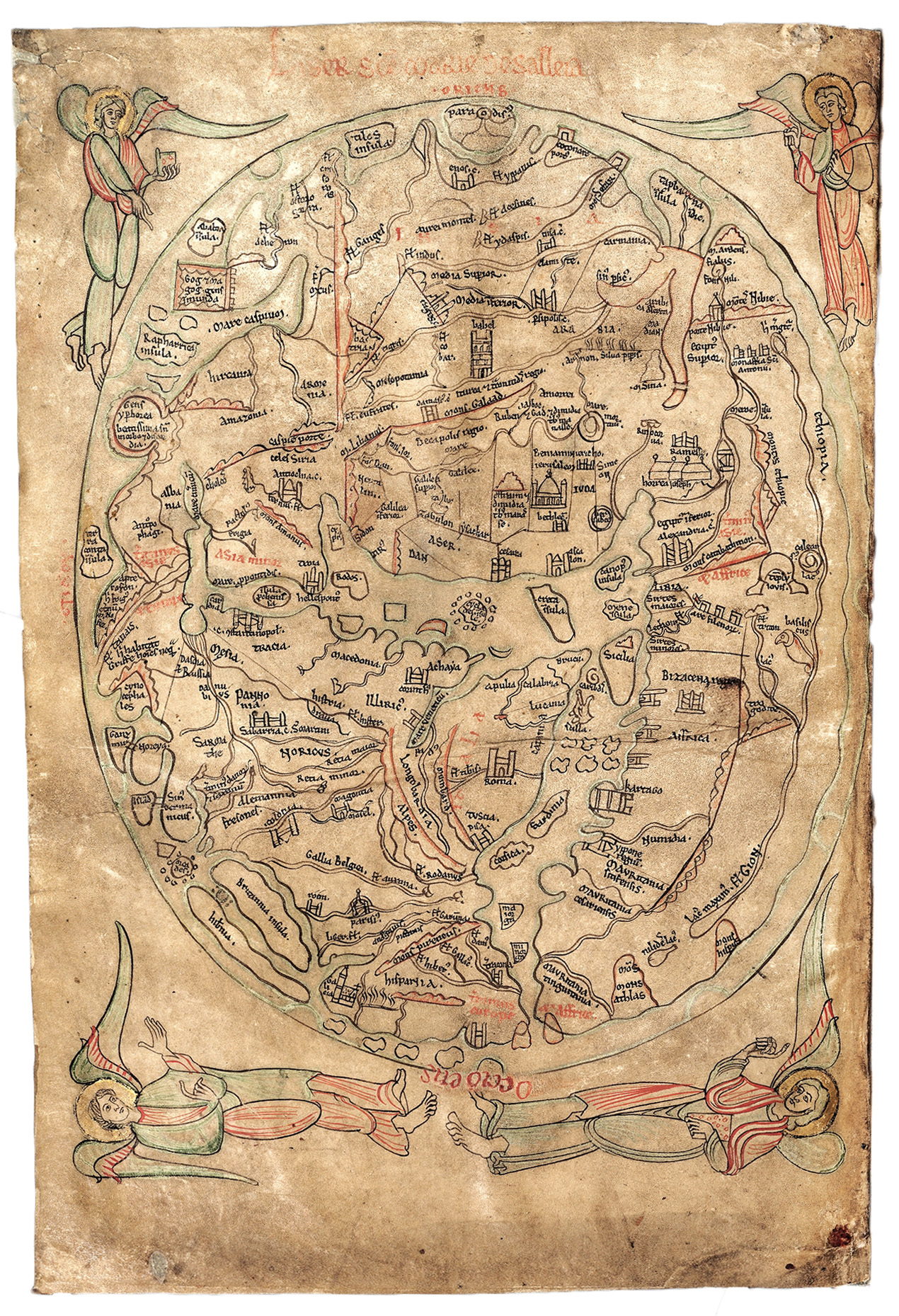
This work is in the public domain in its country of origin and other countries and areas where the copyright term is the author's life plus 100 years or fewer.
You will note that there are four angels.
This is a literalistic reference to Apocalypse 7:1. This doesn't mean that the author believed the earth to be flat, it just means the map is concentrating on what is presumed to be the land hemisphere. In actual fact, as discovered later, the Atlantic isn't on the Western edge of the land hemisphere, it's a water wedged inside it (with some of the displaced tectonics showing up around Baffin Bay, I'd say).
So, given this iconographic tradition, I'm certain I'm right to take the four corners as literal. The angels are also placed, as I place the corners, in the roughly NW, NE, SE and SW of the land hemisphere (or the truncated version they knew of it).
This is one item I'd note.
Another one is this. It was a piece of art. A personnalised art work accompanying the book Imago Mundi by Honorius of Autun. This specific map, smaller than an A4, only exists on this page of a copy of this book, i e second page (folio 1v) of manuscript 66 at Corpus Christi College, Cambridge.
https://en.wikipedia.org/wiki/Sawley_map
There are no follow up pictures that I know of*. No picture of Brittany or of the Holy Land or of Egypt or of Russia. No, there is no higher resolution than c. 1/2 the actual land hemisphere on 20 cm × 30 cm or 11.8 in × 7.9 in. If you are a general, it may be OK as a way to figure out a general travel route from Scotland to the Holy Land, for a Crusade, for instance, but it's not sth you can use in order to adapt a strategy to the actual terrain of an area.
Such smaller areas shown on maps of higher resolution didn't enter into the ceremonial purpose of viewing the inhabited world between the four angels of Apoc. 7:1. Nor were they needed to figure out a sea route across the Mediterranean or the North Sea.
Also:
Around 1,100 mappae mundi are known to have survived from the Middle Ages. Of these, some 900 are found in illustrated manuscript books and the remainder exist as stand-alone documents.
https://en.wikipedia.org/wiki/Mappa_mundi
To modern eyes, mappae mundi can look superficially primitive and inaccurate. However, mappae mundi were never meant to be used as navigational charts and they make no pretence of showing the relative areas of land and water. Rather, mappae mundi were schematic and were meant to illustrate different principles. The simplest mappae mundi were diagrams meant to preserve and illustrate classical learning easily. The zonal maps should be viewed as a kind of teaching aid – easily reproduced and designed to reinforce the idea of the Earth's sphericity and climate zones. T-O maps were designed to schematically illustrate the three land masses of the world as it was known to the Romans and their medieval European heirs.
As I said. Few and not very useful in the practical sense, apart from being a teaching aid. A very ligne claire or Hergé version of an image d'Épinal.
Even their existence is due to some cultural factors that cannot be presumed for just each and every kind of society with a similar level of technology.
Why do I mention this? The fact is, I gave an answer on why the Witchking of Angmar didn't know where the Shire was, even though it was part of the Northern kingdom, of Arnor, and the Witchking conquered it. Many had stated the Witchking didn't know the hobbits called it The Shire. I stated, the Witchking couldn't have found it on a map, because he didn't have any.
And he didn't have any, because maps were not an everyday object.
If Guderian wants to invade Russia or if Zhukov wants to take Berlin, they have no problems getting maps of enemy territory, because local and regional maps are everyday objects, printed in the millions. This is not how Attila the Hun got into France or even how the Teutonic order (as far as I know) planned their failed attempt at Tannenberg in 1410. Neither of them could trust someone to sneak in as a civilian behind enemy lines and just buy a map in a shop. There were no shops where you could buy maps. They were luxury items.
Now, Third Age 1409 and the previous and ensuing centuries is basically meant to be reminiscent of the Dark Ages or Age of Migrations, but a bit more devastating (mimicking the depopulation of much of Europe prior to the migration from Yamnaya). In Third Age 3018 and 3019 (main setting of Lord of the Rings), it's 1418 / 1419 in the Shire calendar, and that is a pretty good indication of the part of the Middle Ages that Tolkien was thinking of, in part, (like the end involves an alternative ending to the siege of Constantinople, one in which the invader is driven back).
The second best attack** on Tolkien's plotting turns around the equivalent of pretending that King Arthur could have walked into a shop to buy maps for the area around Constantiniple, in Nennius. Monty Python might have done that to the Arthuriad, but Tolkien wouldn't.
Hans Georg Lundahl
Nanterre UL
Pentecost Thursday
28.V.2026
PS, if for some reason you still don't get it, one influence Tolkien was on me was getting into the real Christian Middle Ages a bit more than the usual Disney slop or worse./HGL
*I'm by far no expert on this manuscript or the whole work, so there might be a surprise in for me. I only know it from wikipedia. ** The first and third best attacks are about getting into Morder, company of the ring versus armies of Gondor.


No comments:
Post a Comment